Water is the lifeblood of our community. We strive to share information to encourage the sustainable management of our water resources.
Also called the “Memphis Sand Aquifer”, or the “Sparta Aquifer” outside of Tennessee, the underground formation is well known for its ancient, clear water. Residents, industries, decision makers and visitors should all know about the source of their drinking water – and the threats facing its sustainability. CAESER has conducted research on the unique resource for over 25 years, so here’s your crash course!
The information on this page is meant to be shared – feel free to tweet, post, email and text the content and images below.
Table of Contents
About the Memphis Aquifer
Groundwater in the Mid-South
Shelby County, Tennessee is fortunate to get its drinking water supply from deep underground. The Memphis aquifer (also known as Sparta aquifer or Memphis Sand) is the primary water supply, with some wells pumping from the deeper Fort Pillow aquifer. If the land beneath us was cut southeast to northwest, you would get an inside look at the Mississippi embayment as shown in this diagram. The layers in tan/blue are comprised primarily of sand saturated with water: these are called aquifers. The aquifers are separated by the gray layers made of clay, a dense material that pressurizes the groundwater and protects it from contamination. When the clay is absent, the groundwater is more prone to contamination. The brown layer just below Memphis also contains water and is often referred to as the shallow aquifer. It is made of silt, gravel, sand, and clay deposited by rivers and wind. In each layer of the Mississippi embayment, the water moves at different rates and directions, which makes understanding this resource very challenging.
Geology below the Mid-South: a cross-section that reveals the Memphis aquifer.
Mississippi Embayment
Unique Geology of the Mid-South
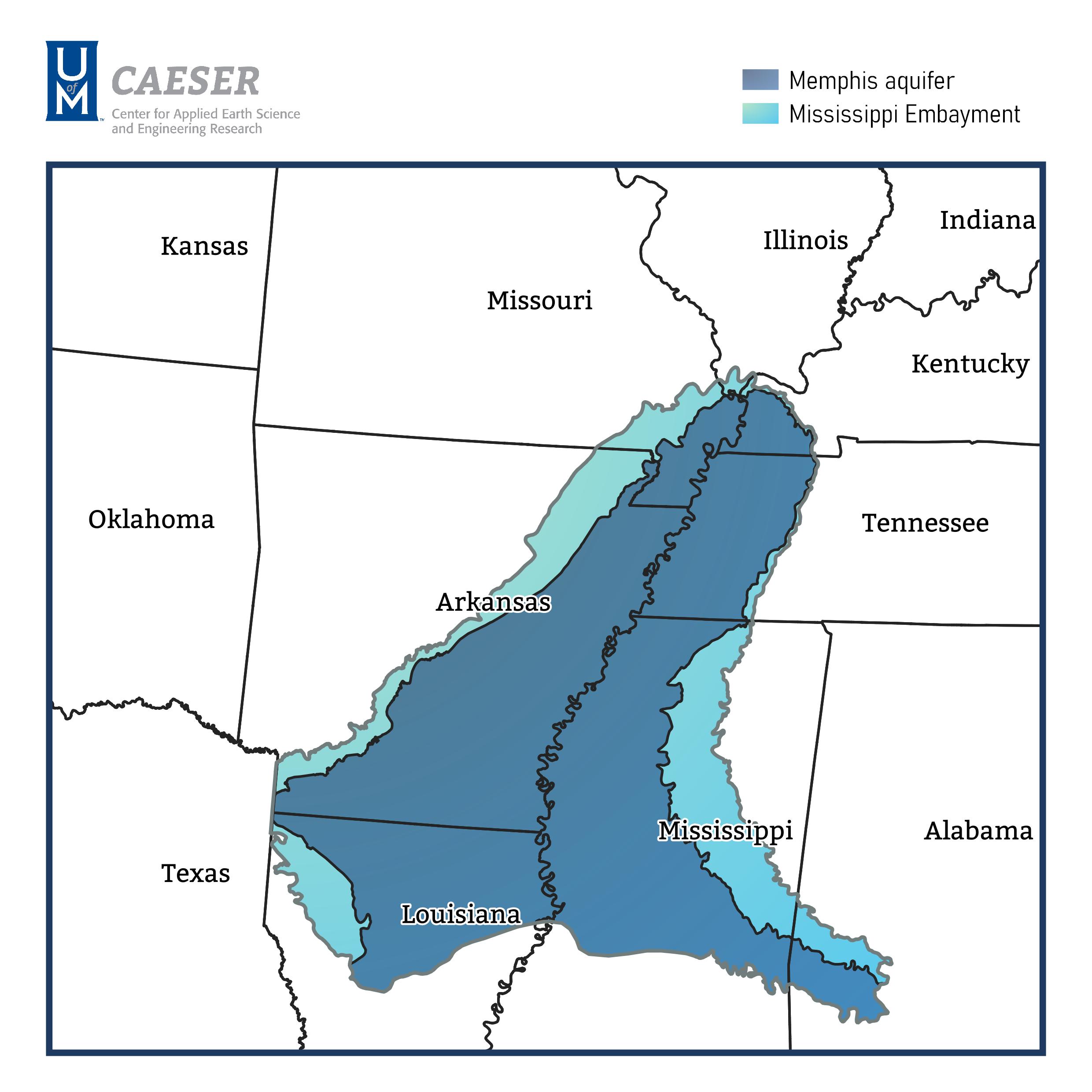
The light blue outline shows the boundaries of a vast groundwater system called the Mississippi embayment. It was formed about 70 million years ago when volcanic activities subsided, causing the land to cool and sink. A trough-shaped depression was left behind which allowed the ocean to wash inland. Alternating layers of sand and clay were deposited over millions of years that make up the aquifer system we rely on today. The total area covers portions of nine states! The darker blue outline shows the boundaries of the Memphis aquifer within the Mississippi embayment.
On the surface of this region there are many rivers and lakes, but the majority of water used in West Tennessee, Eastern Arkansas and Northern Mississippi is pumped from underground aquifers and used by residents, industries, factories, and farmers. It is a shared resource with many demands.
Bird's eye view of the Mississippi Embayment system and boundaries of the Memphis aquifer.
Water Quality Threats
Breaches and Industrial Pollutants
Groundwater from the Memphis aquifer is naturally filtered by the sand, very slowly over time. Most water pumped from the Memphis aquifer is over 2,000 years old with low levels of impurities. Its protective clay layer acts as a barrier to the shallow aquifer, which is known to be polluted in places throughout Shelby County from decades of modern human activity. Over the years, researchers have discovered breaches in the upper protective clay layer where it is missing or thin. This creates a connection between the shallow aquifer and the Memphis aquifer that can impact drinking water quality. The map depicts 36 suspected and 6 known breach locations identified so far.
CAESER has been the primary source of new information about the Mississippi embayment in West Tennessee. Current investigations are underway to further map breaches and understand their potential water quality impacts to the Memphis aquifer. To see more information on our research go to our MLGW Aquifer Study page.
Vulnerable areas of the aquifer in Shelby County, Tennessee.
Recharge Zone
Groundwater Recharge - Water in the Memphis Aquifer
The light green band running throughout West Tennessee in the map is an area where the clay layer protecting the Memphis aquifer is absent and sandy aquifer is exposed near the ground. This is called the “recharge zone” because it allows rain and river water to filter directly into the aquifer, replenishing it. Unfortunately, the rate of recharge is poorly understood and is difficult to measure. Is water extracted from the Memphis aquifer faster than it is naturally replenished? No other area in the Mississippi embayment directly recharges the Memphis aquifer from rainfall making West Tennessee a crucial component of this vast aquifer and its sustainability.
CAESER has launched a new project to estimate recharge to the aquifer. Understanding the complex, natural systems below ground is no easy task and research should continue to ensure there is a sustainable water supply far into the future.
The aquifer sands come to the surface in this green area known as the recharge zone.
Additional Resources
Memphis Aquifer Discovery Story
Deep, down below ground, the Memphis aquifer was discovered in downtown Memphis, TN in the 1880’s. Peer into the history with photos of the gusher!
We have over two decades of published studies and reports on the groundwater resources in West Tennessee. View the most relevant and interested on our Publications Page!